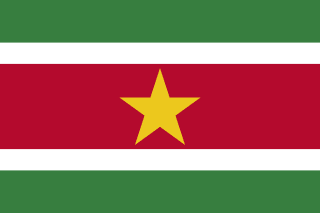
Suriname
Republic of Suriname
Population: UN WPP 2024, revision 1, projection for 1 July 2026. Sources and methodology.
Geography and territory
Suriname, covering 163,820 square kilometers, is the smallest country in South America. Located on the northeastern coast of the continent, it borders Guyana to the west, French Guiana to the east, Brazil to the south, and the Atlantic Ocean to the north. Despite its modest size by South American standards, the country holds one of the largest expanses of untouched rainforest in the world, with roughly 93 percent of its territory covered in forest.
Suriname’s geography divides into two main zones. The coastal strip, narrow and low-lying, is home to nearly the entire population and economic activity. This zone, much of it below sea level, is protected by dikes and drainage systems inherited from the Dutch colonial era. The interior of the country rises gradually toward the highlands of the Guiana Shield, with hills, plateaus, and mountains covered in dense, largely uninhabited forest.
Rivers serve as the primary means of transportation in the interior. The Suriname River, the Marowijne, which forms the border with French Guiana, the Corantijn, bordering Guyana, and the Coppename cut through the territory from south to north, forming waterfalls and rapids as they cross the rocky shield before emptying into the Atlantic. Suriname’s biodiversity is extraordinary, with more than 5,000 species of vascular plants, 700 bird species, and wildlife that includes jaguars, sloths, river dolphins, and hundreds of frog species.
With a population of roughly 639,850 spread across 163,820 square kilometers, Suriname has one of the lowest population densities in the world, and its capital, Paramaribo, is home to nearly half the country’s residents, leaving the rainforested interior almost entirely uninhabited outside a scattering of Maroon and indigenous villages along the rivers.
History
The territory of Suriname was originally home to Amerindian peoples, including the Arawak and Carib. Europeans arrived in the sixteenth century, but it was in the seventeenth century that the English established the first permanent colony. In 1667, under the Treaty of Breda, the Dutch exchanged the colony of New Amsterdam, present-day New York, with England for Suriname, a trade remembered as one of the most curious in colonial history.
During the Dutch colonial era, Suriname became a plantation economy built on sugar, coffee, and cocoa, sustained by the labor of enslaved Africans. After the abolition of slavery in 1863, the Dutch brought indentured laborers from British India, the Dutch East Indies (present-day Indonesia), China, and other regions, shaping the multiethnic society that characterizes the country today. Maroons, descendants of escaped slaves who formed self-governing communities in the rainforest, constitute a unique cultural group.
Suriname gained independence from the Netherlands on November 25, 1975. The early years of independence were marked by a 1980 military coup led by Desi Bouterse, a period of authoritarian rule, and an internal civil war from 1986 to 1992. Democracy has gradually taken hold, though political and economic challenges persist. Suriname is the youngest independent country in South America.
Bouterse himself would later be elected president through democratic means, serving two terms between 2010 and 2020 despite a prior conviction linked to the 1982 killing of political opponents during his military rule, a controversial chapter that continues to shape debates about accountability and reconciliation in Surinamese politics today.
Culture and society
Surinamese culture is among the most diverse and fascinating on the continent, the product of coexisting Amerindian, Maroon, descendants of enslaved Africans, Hindustani, of Indian origin, Javanese, of Indonesian origin, Chinese, European, and mixed-heritage communities. This ethnic multiplicity is reflected in a variety of languages, religions, festivals, and culinary traditions that coexist within a relatively small territory.
Sranan Tongo, an English-based creole language with Dutch, Portuguese, and African influences, functions as a lingua franca among the different communities, alongside official Dutch. Religious and cultural celebrations include Hindu Diwali, Muslim Eid al-Fitr, Chinese New Year, Christmas, Keti Koti, the day marking the emancipation from slavery, and the winti ceremonies of Maroon communities, which blend African spirituality with elements of the New World.
Paramaribo, the capital, is a UNESCO World Heritage site thanks to its historic center, which displays a distinctive combination of Dutch colonial wooden architecture. What stands out is the coexistence, within a few blocks, of a synagogue beside a mosque, along with Christian churches, Hindu temples, and Chinese temples, visible testimony to Surinamese religious tolerance. Kaseko music, a genre fusing African rhythms with Caribbean influences and jazz, is the country’s most representative musical expression.
Economy
Suriname’s economy relies heavily on the extraction of natural resources, with mining as the dominant sector. Gold has become the leading export product, from both industrial operations and small-scale artisanal mining. Bauxite, which for decades powered the economy, has declined in relative importance, while offshore oil and gas exploration represents a promising economic frontier.
Agriculture, though contributing a smaller share of GDP, employs a significant segment of the population. Rice is the main crop, grown both for domestic consumption and export, followed by banana, tropical fruit, and timber. Fishing, particularly for shrimp, is another important export sector. The domestic market is limited by the country’s small population, making foreign trade a critical factor for the economy.
Suriname faces significant economic challenges, including volatile commodity prices, limited production diversification, infrastructure constraints, and an oversized public sector. Ecotourism represents an important development opportunity, given that the country holds one of the largest stretches of pristine rainforest in the world. Cooperation with the Netherlands and international organizations remains relevant to the country’s development, and recent offshore gas discoveries have raised hopes of a new revenue stream that could help stabilize public finances in the years ahead.
Food and cuisine
Surinamese cuisine reflects the country’s ethnic diversity in a way found nowhere else in South America. Roti, a flatbread of Indian origin filled with chicken curry, potato, and egg, is perhaps the country’s most popular and accessible dish, sold at street stalls and restaurants alike. Javanese influence brings dishes such as nasi goreng, fried rice, and bami goreng, fried noodles, adapted to local tastes.
Saoto, a chicken soup with bean sprouts, egg, thin noodles, and Javanese-influenced spices, is one of the most widely eaten dishes. Pom, a gratin of grated pomtajer, a taro-like root, with chicken or meat, is the quintessential festive dish, prepared especially for Christmas and family celebrations. Moksi alesi, mixed rice with beans, meat, and coconut, and bakabana, fried plantain with peanut sauce, are other everyday classics.
The flavors of Maroon cooking, based on rainforest ingredients such as the awara palm, kwak, toasted grated cassava, and taro root, add a unique dimension. Tropical fruit is abundant, with passion fruit, guava, mango, star fruit, and watermelon appearing in juices and desserts. Surinamese rum and Parbo beer, brewed locally since 1929, accompany meals and celebrations.
Tourism and landmarks
Brownsberg Nature Park, about two hours from Paramaribo, is the country’s most accessible nature reserve. From its plateau at 500 meters, visitors take in spectacular panoramas of the rainforest and Lake Brokopondo, the country’s largest reservoir. Waterfalls such as Irene Falls and Mazaroni Falls lie along forest trails where monkeys, toucans, and an astonishing variety of butterflies can be spotted.
Paramaribo, the capital, offers a unique urban experience centered on its UNESCO World Heritage historic core. White-painted colonial wooden buildings, the Cathedral of St. Peter and St. Paul, one of the largest wooden structures in the Western Hemisphere, the Presidential Palace, the central market, and the riverside promenade of the Waterkant form a charming urban landscape. The close proximity of temples from different religions within a few blocks is a cultural attraction without equal.
The indigenous village of Galibi, at the mouth of the Marowijne River, is one of the most important sea turtle nesting sites in the western Atlantic, where four turtle species come ashore to lay eggs between February and August. Maroon communities in the interior, accessible by canoe along the rivers, offer authentic cultural immersion into traditions dating back centuries. The Central Suriname Nature Reserve, covering 1.6 million hectares of pristine rainforest, is a UNESCO World Heritage site and one of the largest protected areas of tropical forest in the world.
Fun facts about Suriname
- Suriname is the smallest and least populous country in South America, with a territory covered 93 percent by rainforest
- The country was exchanged for New Amsterdam, present-day New York, under the 1667 Treaty of Breda, when the Dutch ceded Manhattan to the English in order to keep Suriname
- Paramaribo is one of the few cities in the world where a synagogue and a mosque stand side by side, a symbol of the country’s religious coexistence
- Suriname is the only Dutch-speaking country in South America and one of the few territories outside Europe where Dutch is an official language
- The Central Suriname Nature Reserve, a UNESCO World Heritage site, protects 1.6 million hectares of primary rainforest and ranks among the largest and most intact protected areas in the world
Suriname in numbers
Latest World Bank and UNDP observations, each with its own year. “World median” is the middle value among the countries that report the same indicator; “#” ranks from the highest value.
Population since 1960
Suriname had 263,918 people in 1960 and 639,850 in 2025 — 2.4 times as many.
People
65.8% of people live in towns and cities (world median 63.4%). 25.3% are under 15 and 8.2% are 65 or older — a middle-aged population. Women have 2.23 children on average, close to the replacement level of about 2.1.
Economy
The economy grew by 1.8% in real terms in 2025. Consumer prices rose by 9.2% in 2025. Services make up the largest share of output (50.8% of GDP); agriculture contributes 6.8%.
Development and environment
UNDP rates human development in Suriname as high, with an index of 0.722 in 2023 (rank 114 of 193). 87.4% of people use the internet and 99.0% have access to electricity. Forest covers 91.5% of the land (world median 32.8%).
Sources: World Bank, World Development Indicators (CC BY 4.0), most recent observation from 2015 onward; UNDP Human Development Report 2025. Retrieved 2026-10-10. Sector shares need not add up to 100% because taxes and subsidies on products are excluded. Missing values are left blank rather than estimated. Sources and methodology.
Climate of Suriname
Averaged across Suriname, the mean temperature stays between 25.8 °C (January) and 27.7 °C (October) — a swing of only 1.9 °C, so seasons are marked by rainfall rather than by heat.
About 2,277 mm of precipitation falls in a typical year. May is the wettest month (360 mm) and October the driest (53 mm). The wettest stretch is April to June, with 41% of the year's total.
Show monthly values as a table
| Month | Mean °C | Low °C | High °C | Precipitation, mm |
|---|---|---|---|---|
| January | 25.8 | 21.8 | 30.0 | 199 |
| February | 25.8 | 21.7 | 30.1 | 192 |
| March | 26.1 | 22.0 | 30.4 | 193 |
| April | 26.3 | 22.1 | 30.5 | 269 |
| May | 26.3 | 22.3 | 30.4 | 360 |
| June | 26.4 | 22.3 | 30.5 | 307 |
| July | 26.3 | 21.9 | 30.9 | 240 |
| August | 27.1 | 22.2 | 32.0 | 150 |
| September | 27.5 | 22.1 | 32.9 | 69 |
| October | 27.7 | 22.2 | 33.2 | 53 |
| November | 27.3 | 22.2 | 32.5 | 89 |
| December | 26.4 | 22.0 | 30.8 | 157 |
Figures are 1991–2020 averages across the whole land area of Suriname, from the World Bank Climate Change Knowledge Portal, CRU TS 4.08 (CC BY 4.0). They are not readings from one weather station: the capital, the coast and high ground can be much warmer, cooler, wetter or drier.
Travel essentials for Suriname
The practical details visitors ask about first. Traffic in Suriname drives on the left, one of 54 of the 196 countries profiled here that do — see the full list. Mains electricity is 127 V at 60 Hz, so appliances built only for 220–240 V need a voltage converter.
- Emergency number
- 115
- Driving side
- Left
- Plug types
- Type C, Type FC: two round pins (Europlug); F: two round pins with side earth clips (Schuko)
- Voltage
- 127 V60 Hz
- Dialling code
- +597From abroad: your exit code, then 597 and the number
- Currency
- Surinamese Dollar (SRD)
- Time zone
- UTC-3Current local time in Suriname
Compiled from IEC plug and voltage standards, national emergency-service listings and the UN road-traffic conventions. Emergency numbers and local coverage can change — confirm them locally on arrival. Suriname's internet domain is .sr.
Where Suriname ranks in the world
Each position counts only the countries with data in that ranking guide. First place is the highest value — for price levels, the most expensive. Select a card to see the full table.
- Population165th of 196645,256UN projection, July 2026
- Land area90th of 195160,508 km²World Bank, 2023
- Population density189th of 1943.9 per km²World Bank, 2023
- GDP (nominal)157th of 187$4.4BWorld Bank, 2024, current US$
- GDP per capita97th of 187$6,962World Bank, 2024, current US$
- Life expectancy97th of 19473.8 yearsWorld Bank, 2024
- Price level145th of 16531 (US = 100)ICP 2021, household consumption
Bordering countries of Suriname


Compare Suriname with another country
Frequently asked questions about Suriname
What is the capital of Suriname?
The capital of Suriname is Paramaribo.
What is the population of Suriname?
The UN World Population Prospects projection for Suriname is 645,256 people (645,256) on 1 July 2026. National statistical offices may publish different estimates.
What language is spoken in Suriname?
The official language of Suriname is Dutch.
What currency is used in Suriname?
The currency of Suriname is the Surinamese Dollar (SRD).
How big is Suriname?
Suriname covers an area of 163,820 km².
What type of government does Suriname have?
Suriname is a presidential republic.
Which countries border Suriname?
Suriname shares land borders with Guyana, Brazil, France (French Guiana).
What is the highest point in Suriname?
The highest point in Suriname is Juliana Top (1,230 m).


