Nauru
Republic of Nauru
Population: UN WPP 2024, revision 1, projection for 1 July 2026. Sources and methodology.
Geography and territory
Nauru is a tiny raised coral island in the central Pacific Ocean, lying just 42 kilometers south of the equator. At only 21 square kilometers, it is the smallest republic on Earth and the third-smallest country overall, trailing only Vatican City and Monaco. Roughly oval in shape with a coastline of about 19 kilometers, Nauru has no official capital city; Yaren, on the southern coast, serves as the seat of government and de facto administrative center, making Nauru the only country in the world without a formally designated capital.
The island’s geography has been permanently reshaped by phosphate mining, which has stripped away vegetation and topsoil across roughly 80 percent of the interior. A narrow coastal belt, between 100 and 300 meters wide, is the only land suitable for habitation and agriculture, ringing a central plateau known locally as “Topside.” Decades of open-pit extraction have turned Topside into a stark, almost lunar terrain of bare limestone pinnacles. Command Ridge, at just 71 meters, is the island’s highest point.
Buada Lagoon, a small body of brackish water sitting in an interior depression, is Nauru’s only inland water feature and one of the last pockets of tropical vegetation left on the island. A relatively narrow fringing reef surrounds the coastline, and because Nauru has no natural harbor, ships must use artificial channels cut through the reef to reach shore. Freshwater scarcity, soil degradation, and coastal erosion remain critical environmental challenges for this exceptionally small nation.
History
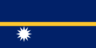
Human settlement on Nauru dates back roughly three thousand years, when Micronesian and Polynesian seafarers first reached the island. Traditional Nauruan society was organized into twelve clans, a heritage still commemorated by the twelve-pointed star on the national flag. Islanders lived by fishing, coconut gathering, and limited cultivation, sustaining a surprisingly prosperous community thanks to the richness of the surrounding sea.
British whaling captain John Fearn became the first European to sight the island, in 1798, naming it “Pleasant Island” for the friendly reception he received. Through the nineteenth century, shipwrecked sailors, traders, and arms dealers disrupted traditional Nauruan society, eventually triggering a tribal war that dragged on for roughly a decade. Germany annexed Nauru into its colonial empire in 1888, and in 1900 the discovery of vast phosphate deposits set the island on a course that would define its modern history.
Following World War I, Nauru was placed under a League of Nations mandate administered jointly by Australia, Britain, and New Zealand. Japanese forces occupied the island during World War II, deporting most of the population to Chuuk in the Caroline Islands. Nauru gained independence on January 31, 1968, and through the 1970s and 1980s enjoyed one of the highest per capita incomes in the world on the strength of phosphate exports. Financial mismanagement and the steady depletion of those reserves, however, brought on a severe economic crisis by the century’s end.
Culture and society
Nauruan culture blends ancestral Micronesian traditions with the layered influence of colonial and modern history. The island’s twelve original clans remain a point of identity, even as modernization and the small size of the community have blurred many of the old tribal distinctions. Nauruan, a language isolate within the Micronesian family with no close linguistic relatives, is the national language and is spoken alongside English in daily life.
Cultural traditions include chants and dances that recount the island’s history, the deeds of ancestors, and its enduring relationship with the sea. Traditional fishing, especially the nighttime capture of the ibija fish using torches during the darkest phases of the moon, survives as a living practice passed down through generations. Sport occupies an outsized role in Nauruan life, and weightlifting in particular has become something of a national pastime, producing international results remarkably disproportionate to the country’s tiny population.
Nauruan society is exceptionally close-knit, with most residents connected through family ties in a community small enough that nearly everyone knows everyone else. The island has no formally defined towns or cities, only fourteen administrative districts that ring the coastline. The Congregational and Catholic churches are the dominant religious institutions. Public health has become a pressing concern, with Nauru recording some of the highest rates of diabetes and obesity in the world, consequences of a dramatic shift away from traditional diet and lifestyle.
Economy
Nauru’s economic history is among the most dramatic of any nation. Phosphate exports made the country extraordinarily wealthy through the 1970s and 1980s, at one point giving Nauru one of the highest per capita incomes on the planet. The government acquired real estate in Australia, purchased aircraft, and built a trust fund that once held billions of dollars. Corruption, poor investment decisions, and reckless spending, however, squandered much of that fortune.
As phosphate reserves neared exhaustion by the end of the twentieth century, the Nauruan economy collapsed. In the years that followed, the country pursued controversial ways to generate revenue, including passport sales, allegations of money laundering, and, most significantly, hosting an offshore processing center for asylum seekers on behalf of Australia. Despite ongoing controversy, this regional processing arrangement has become one of the island’s most important sources of income.
With a GDP of roughly $176 million, Nauru today relies on Australian aid, revenue from the detention center, fees from selling tuna fishing licenses within its exclusive economic zone, and the modest phosphate deposits still being extracted. The government continues to pursue economic diversification through commercial fishing, nascent tourism, and rehabilitation of the mined-out interior, though restoring Topside remains an enormous long-term technical and financial undertaking.
Food and cuisine
Traditional Nauruan food is simple, shaped by the island’s isolation and its limited capacity for agriculture. The historic diet centered on fresh fish caught along the reef and in surrounding waters, supplemented by coconut, pandanus, breadfruit, and the few crops that Nauru’s coral-derived soils could support. Torch fishing for ibija at night was more than a subsistence technique; it functioned as a communal and cultural event that brought the island together.
Coconut, in nearly every form, was historically the most important food resource: fresh or dried flesh for eating, milk for cooking, water for drinking, and oil for countless other uses. Pandanus, whose fruit is processed into a sweet, nutrient-dense paste, and breadfruit, roasted or boiled, rounded out the traditional diet. Celebrations traditionally featured feasts of assorted fish, pork when available, and coconut- and fruit-based dishes.
The arrival of phosphate wealth transformed Nauruan eating habits dramatically. Imported staples, including rice, noodles, canned meat, sugary soft drinks, and processed foods, gradually displaced the traditional diet. That dietary shift has contributed to a serious public health crisis, with Nauru posting some of the highest diabetes and obesity rates recorded anywhere in the world. Government and community initiatives now promote a return to fresh, locally sourced food, though dependence on imports remains high.
Tourism and landmarks
Nauru is among the least-visited countries on Earth, welcoming only a few hundred tourists in a typical year. Yet its sheer rarity draws a small number of intrepid travelers fascinated by one of the world’s most remote and unusual nations. The entire island can be circled by road in under an hour, offering a concentrated tour of striking landscape contrasts and an extraordinary national story.
The devastated interior known as Topside presents a surreal landscape of bare limestone pinnacles stretching across most of the island, a stark visual record of decades of phosphate extraction. Though born of environmental destruction, this lunar terrain exerts a strange fascination of its own. Buada Lagoon, a pocket of tropical greenery amid the mining-scarred interior, and Command Ridge, which still holds Japanese artillery positions from World War II, are the island’s principal points of interest inland.
Along the coast, visitors find coral beaches, snorkeling on the surrounding reef, and dramatic sunsets over the equatorial Pacific. Simply spending time within a community of roughly 12,000 people, where nearly everyone is acquainted, is itself a singular social experience. Nauru’s Parliament, one of the smallest legislative buildings in the world, and its war memorial round out the list of sights. With almost no tourism infrastructure to speak of, a visit to Nauru is a genuine adventure, best suited to travelers seeking a destination truly off the map.
Fun facts about Nauru
- Nauru is the smallest republic in the world and the third-smallest country overall, after Vatican City and Monaco, covering just 21 square kilometers.
- During the 1980s, phosphate wealth gave Nauru one of the highest per capita incomes on Earth, before mismanagement and resource depletion pushed the country toward economic collapse.
- Nauru is the only country in the world without an official capital; Yaren serves as the seat of government without holding formal capital status.
- The island has no rivers, streams, or surface freshwater systems, relying almost entirely on collected rainwater and desalination.
- Nauru records some of the highest rates of diabetes and obesity in the world, a legacy of the shift from a traditional diet to imported processed food.
- The twelve-pointed star on Nauru’s flag represents the twelve traditional clans that make up the island’s indigenous society.
Nauru in numbers
Latest World Bank and UNDP observations, each with its own year. “World median” is the middle value among the countries that report the same indicator; “#” ranks from the highest value.
Population since 1960
Nauru had 4,607 people in 1960 and 12,025 in 2025 — 2.6 times as many.
People
100.0% of people live in towns and cities (world median 63.4%). 37.2% are under 15 and 3.0% are 65 or older — a young population. Women have 3.29 children on average, above the replacement level of about 2.1.
Economy
The economy grew by 2.1% in real terms in 2025.
Development and environment
UNDP rates human development in Nauru as high, with an index of 0.703 in 2023 (rank 124 of 193). 83.0% of people use the internet and 100.0% have access to electricity. Forest covers 0.0% of the land (world median 32.8%).
Sources: World Bank, World Development Indicators (CC BY 4.0), most recent observation from 2015 onward; UNDP Human Development Report 2025. Retrieved 2026-10-10. Sector shares need not add up to 100% because taxes and subsidies on products are excluded. Missing values are left blank rather than estimated. Sources and methodology.
Climate of Nauru
Averaged across Nauru, the mean temperature stays between 27.3 °C (September) and 28.0 °C (May) — a swing of only 0.7 °C, so seasons are marked by rainfall rather than by heat.
About 2,435 mm of precipitation falls in a typical year. January is the wettest month (261 mm) and June the driest (170 mm). Rain is spread fairly evenly through the year.
Show monthly values as a table
| Month | Mean °C | Low °C | High °C | Precipitation, mm |
|---|---|---|---|---|
| January | 27.8 | 24.8 | 30.9 | 261 |
| February | 27.9 | 24.9 | 30.9 | 223 |
| March | 27.8 | 24.8 | 30.8 | 219 |
| April | 27.8 | 24.7 | 31.0 | 209 |
| May | 28.0 | 24.9 | 31.1 | 186 |
| June | 27.9 | 24.8 | 31.0 | 170 |
| July | 27.9 | 24.7 | 31.1 | 209 |
| August | 27.8 | 24.5 | 31.1 | 178 |
| September | 27.3 | 24.0 | 30.7 | 172 |
| October | 28.0 | 24.7 | 31.3 | 185 |
| November | 28.0 | 24.8 | 31.2 | 176 |
| December | 27.9 | 24.9 | 30.9 | 247 |
Figures are 1991–2020 averages across the whole land area of Nauru, from the World Bank Climate Change Knowledge Portal, CRU TS 4.08 (CC BY 4.0). They are not readings from one weather station: the capital, the coast and high ground can be much warmer, cooler, wetter or drier.
Travel essentials for Nauru
The practical details visitors ask about first. Traffic in Nauru drives on the left, one of 54 of the 196 countries profiled here that do — see the full list. Mains electricity is 240 V at 50 Hz, so devices made only for 110–120 V (common in North America) need a converter unless they are dual-voltage — most phone and laptop chargers are.
- Emergency number
- 110Ambulance 111 · Fire 112
- Driving side
- Left
- Plug types
- Type II: two angled flat pins plus earth
- Voltage
- 240 V50 Hz
- Dialling code
- +674From abroad: your exit code, then 674 and the number
- Currency
- Australian Dollar (AUD)
- Time zone
- NRT (UTC+12)Current local time in Nauru
Compiled from IEC plug and voltage standards, national emergency-service listings and the UN road-traffic conventions. Emergency numbers and local coverage can change — confirm them locally on arrival. Nauru's internet domain is .nr.
Where Nauru ranks in the world
Each position counts only the countries with data in that ranking guide. First place is the highest value — for price levels, the most expensive. Select a card to see the full table.
- Population194th of 19612,101UN projection, July 2026
- Land area193rd of 19520 km²World Bank, 2023
- Population density10th of 194594 per km²World Bank, 2023
- GDP (nominal)186th of 187$168MWorld Bank, 2024, current US$
- GDP per capita66th of 187$14,048World Bank, 2024, current US$
- Life expectancy180th of 19462.3 yearsWorld Bank, 2024
Compare Nauru with another country
Frequently asked questions about Nauru
What is the capital of Nauru?
The capital of Nauru is Yaren.
What is the population of Nauru?
The UN World Population Prospects projection for Nauru is 12,101 people (12,101) on 1 July 2026. National statistical offices may publish different estimates.
What language is spoken in Nauru?
The official language of Nauru is Nauruan, English.
What currency is used in Nauru?
The currency of Nauru is the Australian Dollar (AUD).
How big is Nauru?
Nauru covers an area of 21 km².
What type of government does Nauru have?
Nauru is a parliamentary republic.
What is the highest point in Nauru?
The highest point in Nauru is Command Ridge (71 m).


