Lesotho
Kingdom of Lesotho
Population: UN WPP 2024, revision 1, projection for 1 July 2026. Sources and methodology.
Geography and territory
Lesotho holds a singular place on the world map: entirely surrounded by South Africa, it is one of the few enclaved states on Earth and the only country whose territory lies wholly above 1,000 meters in elevation. Covering 30,355 square kilometers with an average elevation of 2,161 meters, Lesotho has earned the poetic nickname “Kingdom in the Sky,” a fitting description of its mountainous, elevated character.
The Maloti and Drakensberg mountains dominate Lesotho’s landscape, forming a spectacular natural barrier along the eastern border with South Africa. Thabana Ntlenyana, at 3,482 meters, is the country’s highest point and the tallest peak in southern Africa. The eastern highlands offer landscapes of extraordinary beauty, with deep valleys, steep gorges, waterfalls, and sandstone rock formations that hold rock paintings left by the San, among the region’s earliest inhabitants.
The Orange River, South Africa’s longest, rises in the mountains of Lesotho and gathers numerous tributaries draining the country’s highlands. The Lesotho Highlands Water Project harnesses this abundance through a system of dams and tunnels that transfer water to South Africa, generating substantial revenue from water and electricity sales. The climate is continental, with mild summers and harsh winters during which the peaks are blanketed in snow, a rare phenomenon in sub-Saharan Africa that has allowed the continent’s only ski resort, Afriski, to develop.
History
Lesotho’s history is inseparable from the Basotho people and the vision of its founder, King Moshoeshoe I, one of the shrewdest and most far-sighted African leaders of the 19th century. In the 1820s, Moshoeshoe gathered clans scattered by the Zulu wars (known as the difaqane or mfecane) and settled them at the natural fortress of Thaba-Bosiu, an impregnable plateau that became the cradle of the Basotho nation. From there, through a skillful mix of diplomacy, marriage alliances, and military defense, he built a kingdom that withstood assaults from the Zulu, the Matabele, and Boer settlers.
Facing mounting pressure from the Boers of the Orange Free State, who seized fertile farmland from the Basotho, Moshoeshoe sought British protection, which was granted in 1868. Basutoland, as the protectorate was named, retained considerable autonomy under indirect British administration, preserving the monarchy and traditional power structures. This strategic decision by Moshoeshoe proved decisive, as it kept the territory from being absorbed into South Africa.
Lesotho gained independence on October 4, 1966, with Moshoeshoe II as constitutional king and Leabua Jonathan as prime minister. The following decades were marked by tension between the monarchy and political power, coups, and periods of instability, compounded by economic dependence on South Africa and the devastating effects of the HIV epidemic. Despite these challenges, Lesotho has held on to its national identity and cultural traditions with remarkable tenacity.
Culture and society
Basotho culture is one of the most cohesive and distinctive in southern Africa, unified by a common language, Sesotho, shared traditions, and deep national pride. The Basotho blanket, a thick wool blanket decorated with geometric patterns and worn wrapped over the shoulders like a cloak, is Lesotho’s most recognizable cultural symbol. Worn by both men and women regardless of season, the blanket is far more than outerwear: it is an expression of identity, status, and belonging to the Basotho nation.
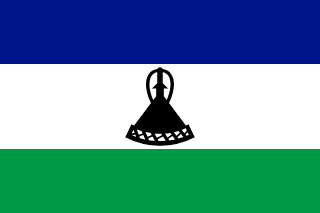
The Basotho conical hat, known as the mokorotlo, is another national icon that even appears on the country’s flag. Woven from braided grass and said by tradition to be inspired by the shape of the mountain of Qiloane near Thaba-Bosiu, the mokorotlo is worn at celebrations, ceremonies, and official events. Traditional Basotho music, played on instruments such as the lesiba (a mouth-blown musical bow) and the setolo-tolo (a mouth instrument), accompanies ceremonial dances celebrating harvests, weddings, and rites of passage.
Male and female initiation rites continue to play a central role in the transition to adulthood in Basotho society. Initiation schools, held in the mountains during winter, pass on ancestral knowledge, community values, and social responsibilities to young people. The system of pitsos, community assemblies where citizens debate matters of public interest, reflects a participatory democratic tradition that predates colonization and remains alive in rural Lesotho today.
Economy
Lesotho’s economy is deeply tied to that of its sole neighbor, South Africa, which absorbs most of its exports and serves as the primary source of employment for Basotho migrant workers. Historically, remittances sent home by Basotho miners working in South Africa’s gold and diamond mines were the country’s leading source of income. Although this labor migration has declined, remittances remain a vital lifeline for thousands of families.
The textile and garment industry has become Lesotho’s leading manufacturing sector, benefiting from the African Growth and Opportunity Act (AGOA), which grants preferential access to the US market. Dozens of factories, many backed by Asian capital, employ thousands of workers producing clothing for major international brands. The Lesotho Highlands Water Project generates significant income through water sales to South Africa and hydroelectric power generation.
Subsistence agriculture employs most of the rural population, with maize, sorghum, and wheat as the main crops, complemented by sheep and goat herding and the prized Basotho pony. Soil erosion, worsened by overgrazing and climate change, has sharply reduced agricultural productivity. Diamond mining, led by the Letseng mine, which produces some of the largest and most valuable gemstones in the world, brings significant revenue to the government, though its impact on local employment remains limited.
Food and cuisine
Lesotho’s cuisine reflects the country’s mountainous conditions and the agropastoral traditions of the Basotho people, with hearty, warming dishes suited to the cold climate of the highlands. Papa, a thick maize-flour dough cooked in boiling water until firm and elastic, is the fundamental staple of the Basotho diet, served at nearly every main meal alongside meat stews, vegetables, or legume sauces.
Moroho, a preparation of leafy greens similar to spinach cooked with tomato, onion, and spices, is the most common vegetable accompaniment to papa. Lekhotloane, a stew of beef or goat slow-cooked with vegetables and local spices, is the great festive dish, reserved for family celebrations, weddings, and initiation ceremonies. Dried meat, or biltong, made by salting and sun-drying, is a traditional preservation method that carries the household through the long winter months.
Fermented milk, known as mafi, is a nourishing everyday drink consumed with meals or on its own as a snack. Traditional Basotho beer, joala, brewed from fermented sorghum, is a socially important drink shared from communal vessels at gatherings and festivities. Bread baked in a cast-iron pot over coals, a technique inherited from early European missionaries, is another specialty especially common in rural areas.
Tourism and landmarks
Lesotho offers a distinctive brand of nature and adventure tourism centered on its spectacular mountain scenery and well-preserved traditional culture. Sehlabathebe National Park, a UNESCO World Heritage Site as part of the Maloti-Drakensberg Transfrontier Park, protects serenely beautiful mountain landscapes, with alpine meadows, fantastical rock formations, crystalline waterfalls, and thousands-year-old San rock paintings.
The Afriski resort, situated above 3,000 meters in the Maloti Mountains, is the only winter sports resort in sub-Saharan Africa. Though modest by European standards, it offers ski and snowboard slopes between June and August, along with year-round activities like hiking, mountain biking, and stargazing under exceptionally clear skies. The Sani Pass, a vertiginous mountain road connecting Lesotho to KwaZulu-Natal in South Africa, is one of the continent’s most spectacular and challenging drives.
Thaba-Bosiu, the sacred mountain where Moshoeshoe I founded the Basotho nation, is a site of historical pilgrimage offering panoramic views of the surrounding valley and remains of the original fortifications. The Maletsunyane Falls, dropping 192 meters, rank among the tallest in Africa and offer the chance to abseil or simply admire their majesty from natural viewpoints. Horseback rides through the mountains on the hardy Basotho pony provide an authentic experience, offering access to remote villages and landscapes unreachable by any other means.
Fun facts about Lesotho
- Lesotho is the only country in the world whose entire territory lies above 1,000 meters in elevation.
- The Letseng diamond mine, at 3,100 meters, is the highest diamond mine in the world and has produced some of the largest and most valuable gems ever found.
- Afriski is the only ski resort in sub-Saharan Africa, proof that skiing is possible in Africa too.
- The hardy, sure-footed Basotho pony is the traditional means of mountain transport and appears on the country’s coat of arms.
- The mokorotlo, the Basotho conical hat, has been depicted on the national flag since 2006.
- Lesotho sells water to South Africa through one of Africa’s most ambitious hydraulic engineering projects, the Lesotho Highlands Water Project.
Lesotho in numbers
Latest World Bank and UNDP observations, each with its own year. “World median” is the middle value among the countries that report the same indicator; “#” ranks from the highest value.
Population since 1960
Lesotho had 736,500 people in 1960 and 2.4 million in 2025 — 3.2 times as many.
People
44.7% of people live in towns and cities (world median 63.4%). 34.1% are under 15 and 3.9% are 65 or older — a young population. Women have 2.66 children on average, above the replacement level of about 2.1.
Economy
The economy grew by 2.0% in real terms in 2025. Consumer prices rose by 4.3% in 2025. Services make up the largest share of output (55.6% of GDP); agriculture contributes 6.5%.
Development and environment
UNDP rates human development in Lesotho as medium, with an index of 0.550 in 2023 (rank 167 of 193). 51.8% of people use the internet and 60.6% have access to electricity. Forest covers 1.1% of the land (world median 32.8%).
Sources: World Bank, World Development Indicators (CC BY 4.0), most recent observation from 2015 onward; UNDP Human Development Report 2025. Retrieved 2026-10-10. Sector shares need not add up to 100% because taxes and subsidies on products are excluded. Missing values are left blank rather than estimated. Sources and methodology.
Climate of Lesotho
Averaged across Lesotho, the warmest month is January (17.7 °C) and the coolest is June (6.4 °C), a seasonal swing of 11.3 °C. The annual mean is 12.5 °C.
About 787 mm of precipitation falls in a typical year. January is the wettest month (133 mm) and July the driest (11 mm). The wettest stretch is December to February, with 46% of the year's total.
Show monthly values as a table
| Month | Mean °C | Low °C | High °C | Precipitation, mm |
|---|---|---|---|---|
| January | 17.7 | 11.3 | 24.1 | 133 |
| February | 17.1 | 11.0 | 23.2 | 107 |
| March | 15.6 | 9.4 | 21.7 | 99 |
| April | 12.0 | 5.7 | 18.4 | 53 |
| May | 8.9 | 2.2 | 15.7 | 27 |
| June | 6.4 | −0.8 | 13.5 | 14 |
| July | 6.4 | −0.8 | 13.7 | 11 |
| August | 8.4 | 1.0 | 15.8 | 18 |
| September | 12.1 | 4.5 | 19.8 | 31 |
| October | 13.8 | 6.8 | 20.8 | 74 |
| November | 14.9 | 8.2 | 21.7 | 97 |
| December | 16.3 | 9.8 | 23.0 | 124 |
Figures are 1991–2020 averages across the whole land area of Lesotho, from the World Bank Climate Change Knowledge Portal, CRU TS 4.08 (CC BY 4.0). They are not readings from one weather station: the capital, the coast and high ground can be much warmer, cooler, wetter or drier.
Travel essentials for Lesotho
The practical details visitors ask about first. Traffic in Lesotho drives on the left, one of 54 of the 196 countries profiled here that do — see the full list. Mains electricity is 220 V at 50 Hz, so devices made only for 110–120 V (common in North America) need a converter unless they are dual-voltage — most phone and laptop chargers are.
- Emergency number
- 123Ambulance 121 · Fire 122
- Driving side
- Left
- Plug types
- Type MM: three large round pins (South African)
- Voltage
- 220 V50 Hz
- Dialling code
- +266From abroad: your exit code, then 266 and the number
- Currency
- Lesotho Loti (LSL)
- Time zone
- SAST (UTC+2)Current local time in Lesotho
Compiled from IEC plug and voltage standards, national emergency-service listings and the UN road-traffic conventions. Emergency numbers and local coverage can change — confirm them locally on arrival. Lesotho's internet domain is .ls.
Where Lesotho ranks in the world
Each position counts only the countries with data in that ranking guide. First place is the highest value — for price levels, the most expensive. Select a card to see the full table.
- Population145th of 1962.4 millionUN projection, July 2026
- Land area136th of 19530,360 km²World Bank, 2023
- Population density110th of 19476 per km²World Bank, 2023
- GDP (nominal)167th of 187$2.4BWorld Bank, 2024, current US$
- GDP per capita171st of 187$1,023World Bank, 2024, current US$
- Life expectancy190th of 19457.8 yearsWorld Bank, 2024
- Price level110th of 16539 (US = 100)ICP 2021, household consumption
Bordering countries of Lesotho

Compare Lesotho with another country
Frequently asked questions about Lesotho
What is the capital of Lesotho?
The capital of Lesotho is Maseru.
What is the population of Lesotho?
The UN World Population Prospects projection for Lesotho is 2,389,336 people (2.4 million) on 1 July 2026. National statistical offices may publish different estimates.
What language is spoken in Lesotho?
The official language of Lesotho is Sesotho and English.
What currency is used in Lesotho?
The currency of Lesotho is the Lesotho Loti (LSL).
How big is Lesotho?
Lesotho covers an area of 30,355 km².
What type of government does Lesotho have?
Lesotho is a parliamentary constitutional monarchy.
Which countries border Lesotho?
Lesotho shares land borders with South Africa.
What is the highest point in Lesotho?
The highest point in Lesotho is Thabana Ntlenyana (3,482 m).


